Find out how a student researches the reforestation in a micro-watershed as part of his master's thesis project, exploring its environmental impact and ecological benefits.
Do you know how important it is to manage the risks of disasters and climate change? Do you know the many factors that can trigger these problems and how to solve them? The Master’s in Disaster Risk Management and Climate Governance is one of Structuralia’s top master’s programs, as it provides the knowledge and skills necessary for applied research and the use of instruments and tools for managing these risks. This interesting and in-depth master’s thesis, written by our alumnus Jorge Castro Rivera, is a great reflection of that.
Why did I choose this topic for my master's thesis?
The disaster risk management and climate change management, are two issues that are relevant today, which require us to identify the common ground surrounding the hydroclimatological phenomena and its impacts on the development of human society. In this regard, the thesis provides a general characterization of the Risk Scenario for Torrential Floods in Colombia, the triggering factors, the potential impacts, and how deforestation influences the occurrence of these phenomena, as well as how they are interrelated Reforestation and Carbon Emissions Mitigation on the atmosphere based on land use, particularly through soil conservation practices and vegetation cover.
Key Concepts
Torrential Downpours are «a very fast to extremely fast flow of saturated, non-plastic debris (plasticity index less than 5%), which flows primarily in a confined channel or bed with a steep slope (Hunger et al. 2001). It is one of the most dangerous mass movements due to its sudden onset, high speeds, and long travel distances” (UNGRD, 2017).
.jpg?width=547&height=328&name=MOCOA-TRAGEDIA-2%20(1).jpg)
Photo 1: Flash flood in Mocoa, Colombia, 2018. Source: (Network, 2018)
“Deforestation can be defined as the conversion of forested land to non-forested land. Reforestation and afforestation can be defined as the conversion of non-forested land to forested land, differing only in the length of time during which the land has been without forest. Similarly, an alternative definition of deforestation could be proposed based on a given decrease in canopy cover or carbon density, or on the crossing of one of a sequence of thresholds. Similarly, afforestation and reforestation could also be defined in terms of an increase in canopy cover or carbon density. None of these definitions relates to the concept of land-use change.” (IPCC, 2000).
On the other hand, Carbon capture is defined as such as: “A process in which a relatively pure stream of carbon dioxide (CO2) from industrial and energy-related sources is separated (captured), conditioned, compressed, and transported to a storage site to be isolated from the atmosphere for a long period of time. It is sometimes referred to as “carbon capture and sequestration.”” (IPCC [.-D. V.-O.-O., 2018).
Objectives of the Master's Thesis
The overall objective of the thesis was to conduct An analysis of reforestation as a tool for carbon sequestration and reducing the threat of flash floods in the La Guayabal microshed in the municipality of Cocorná, department of Antioquia, Colombia.
In addition, the goal was to carry out An Analysis of Reforestation as a Tool for Mitigating Threats in a Watershed that is at risk of flash flooding, and to systematically conduct a descriptive analysis of reforestation as a carbon sequestration tool in a watershed that is at risk of flash flooding.
1. Background
Of Colombia’s 32 departments, 7 account for 59% of the areas most susceptible to flash floods: Chocó, Cundinamarca, Antioquia, Boyacá, Tolima, Santander, and Caquetá. Additionally, according to the National Planning Department (DNP), 12.4 million hectares in the country are at risk of severe flash floods, representing 10.8% of the country’s total land area (DNP, 2018)..
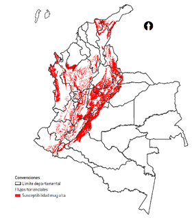
Figure 1: Map of flash floods. Source: (DNP, 2018)
Furthermore, according to the Institute of Hydrology, Meteorology, and Environmental Studies (IDEAM), over the past 30 years, Colombia has lost more than 6 million hectares, that is, 11% of its natural forests (Ministry of Environment and Sustainable Development & IDEAM, 2019). In 2016, the country lost 178,597 hectares, 44% more than was reported in 2015 (124,035 hectares); when compared to previous years— 64,442 hectares in 1990 and 59,021 in 2010, highlights the progressive increase in deforestation in the country (IDEAM, 2014).
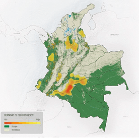
Figure 2: Deforestation rate and areas with natural forests. Source: (Ministry of the Environment and Sustainable Development & IDEAM, 2019)
Finally, the National Greenhouse Gas Inventory According to a study conducted by IDEAM, GHG emissions from deforestation in 2010 accounted for 36% of the country’s total emissions. Similarly, the main emissions have been generated by the deforestation of natural forests converted into pastures (40%), other forested lands (25%), and croplands (11%). (IDEAM P. M., 2016).
On the other hand, reforestation in Colombia, It has enormous potential due to climatic conditions that favor the rapid development of plantations, the soil’s suitability for forestry (54% of the territory), excellent climatic conditions, its geography, and the policies, plans, and strategies that have been launched in the country (Ministry of Environment and Sustainable Development & IDEAM, 2019).
Forest ecosystems, forest plantations, and agroforestry systems mitigate climate change because they sequester carbon in their biomass, dead organic matter, and soils, thereby serving as alternatives for atmospheric carbon sinks. Thus, the ecosystem services provided by forests and forest and agroforestry systems—depending on species composition, precipitation, temperature, and soil characteristics—indicate that forest plantations between 6 and 30 years old store between 0.03 and 0.11 Pg C year⁻¹, which can stabilize CO₂ emissions resulting from deforestation and land-use changes (Patiño Forero, 2018).
The implementation of Clean Development Mechanism (CDM) projects focused on forest plantations, forest conservation, and ecological restoration thus constitutes, a viable alternative for harnessing the country’s potential, mitigating GHG emissions, and reducing the threat of flash floods in the watersheds targeted for intervention (Chavarro M, 2008, as cited in Patiño Forero, 2018).
2. Presentation of the Case Study
To analyze reforestation as a tool for carbon sequestration and mitigating the threat of flash floods in a watershed, a case study was selected based on available information. The case study focuses on the municipality of Cocorná in the department of Antioquia, in the micro-watershed of the Guayabal Creek, a tributary of the Cocorná River. This creek is significant because it is It is a tourist and cultural attraction, supplies the city's aqueduct, and has a Micro-Watershed Planning and Management Plan.
The La Guayabal micro-watershed It covers an area of approximately 1,371.53 hectares (13.71 km2), its main watercourse is the La Guayabal Creek, which is 10.73 km long and supplies the Cocorná municipality’s water system. According to the diagnostic report of the Land Use Plan, the entire La Guayabal micro-watershed is suitable for forestry use, falling into the categories of natural productive/protective forest, conservation, protection and/or special management, and productive-protective plantations; however, the predominant current land use is forestry, at 40.8%, followed by livestock farming at 29.9%, which generates the greatest land-use conflict because it is located within water buffer zones, which are intended to serve a protective function; Finally, agricultural use is also significant in the micro-watershed (MASORA, 2015).
In light of socio-natural threats, the micro-watershed exhibits mass movement phenomena in its middle and lower reaches, associated with land-use conflicts arising from livestock and agricultural activities, as well as its geomorphological characteristics and slope; it is also threatened by torrential floods. The micro-watershed receives high rainfall, estimated at 4,311 mm per year, with a bimodal distribution, which is one of the triggering factors for flash floods as well as mass movement processes (MASORA, 2015).
3. Process and Results Obtained
To determine the protection factor of current land uses in the La Guayabal microshed, which will provide clear criteria for understanding the watershed’s behavior during torrential events, and to use these criteria to establish the necessary management measures, that is, hydrological and forest restoration, There is a methodology based on a parametric model defined using two models: Universal Soil Loss Equation (USLE) and the MModified Universal Soil Loss Equation (MUSLE), which results in a vegetation-based soil protection index (Mintegui Aguirre & Robredo Sánchez, 2008). This index is derived from indicators representing riverine erosion, soil vulnerability to erosion, land topography, vegetation cover, soil management and conservation practices, runoff volume, and peak discharge generated in the watershed (Mintegui Aguirre & Robredo Sánchez, 2008).
The protection ratings ranging from 1.0 (maximum protection) to 0.0 (no protection) and corresponding to each distinct soil type within the watershed. Regarding the slopes in the micro-watershed, 3.15% of the micro-watershed area has a low slope ranging from 0 to 18%, while 9.21% of the area has a lower-middle slope, that is, ranging from 19 to 35%; a medium portion comprising 33.25% of the area, ranging from 36 to 67%; high at 29.03% for the basin, with a range between 68 and 100%; and very high at 25.35%, with a range greater than 100% in slope (CORNARE, 2008). This means that, for most of the micro-watershed area, slopes determine the vegetation protection indices; therefore, land use must be reviewed and managed in order to address the threat of torrential floods to the micro-watershed.
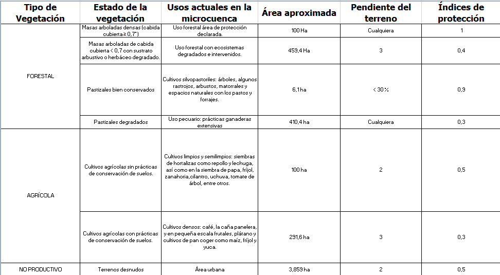
Table 1: Soil protection indices based on vegetation in the La Guayabal microbasin. Source: Prepared by the author based on (Mintegui Aguirre & Robredo Sánchez, 2008)
Starting on methodology proposed by Mintegui Aguirre and Robredo Sánchez, and the information available for the micro-watershed was classified as shown in the table above, the protection index based on the current land-use cover in the micro-watershed. Thus, the 51,18% of the study area has a protection index of 0.3, which corresponds to dense crop cultivation and livestock use, that is, a very low index that requires changes in agricultural and environmental practices to make them more compatible with the land’s suitability for use and to improve soil quality and cover in order to reduce the threat of flash floods.
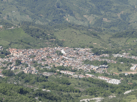
Photo 2: Cocorná, Antioquia, Colombia. Source: Traveling in the Summer
The following uses, with protection factors of 0.4 and 0.5, are defined by the uurban areas, agricultural crops grown without soil conservation practices, and forestry use in degraded and disturbed ecosystems, which are found in areas with moderate slopes (between 18% and 24%), that is, slopes ranging from the onset of erosion to the onset of total washout, and covering an area corresponding to 41.06% of the microshed. These areas also require intervention to enable expanding vegetation cover and implementing soil conservation practices. Finally, there is forest land use in designated protected areas and silvopastoral systems: trees, some crop stubble, shrubs, thickets, and natural areas with pastures and forage, which account for only 7,73% of the micro-watershed’s area and have protection indices of 1.0 and 0.9.
Based on these results, it is clear that in order to Reduce the threat of flash floods in the La Guayabal microshed, it is necessary to increase reforestation, since these efforts increase runoff in the watershed and improve water regulation; they do not contribute to soil erosion but, on the contrary, help mitigate its effects through water interception, infiltration, and retention, in addition to preventing further soil loss, which can contribute sediment to torrential floods.
However, based on an analysis of reforestation as a carbon sequestration tool in the La Guayabal microshed, it appears that forestry projects in Greenhouse gas mitigation measures can be grouped into three types:, the focused on carbon sequestration, that is, controlling deforestation rates, protecting forests, and managing forests, among other things, carbon capture projects, through forest plantations, increased forest cover, agroforestry, and restoration of degraded forests, and carbon offset projects, aimed at replacing fossil fuels (Russo, 2009).
In the case of the subject of this study, and based on the characteristics of the La Guayabal micro-watershed, the agroecological conditions (high precipitation, moderately deep and well-drained soils, good solar radiation, high light levels) promote rapid forest growth and accelerated forest biomass production (CORNARE, 2008), making it feasible to develop projects focused on carbon conservation and carbon sequestration.
Based on the analysis presented in section 7.1 of this document, it is concluded that the micro-watershed has approximately 40% of its area covered by vegetation that protects the soil and contributes to the maintenance and regulation of streamflow, carbon sequestration, temperature regulation, and the conservation and protection of biodiversity, while the remaining 60% consists of crops and pastures, which primarily support the local economy.
That said, and taking into account the characteristics of the micro-watershed, it is feasible to develop Clean Development Mechanism (CDM) projects that include forest plantations and existing forests at a low cost. These projects actions focused on agroforestry systems, shelterbelts, forest plantations, and REDD+ (Reducing Emissions from Deforestation and Forest Degradation) projects can be included as mitigation alternatives in forested areas (Chavarro M, 2008, as cited in (Patiño Forero, 2018)).
Thus, 558.48 of the La Guayabal micro-watershed (defined as areas for environmental restoration, specifically in steep-slope areas, watershed buffer zones, and the upper reaches of the micro-watershed) are suitable for carbon conservation projects, According to the analysis presented in the previous section, 136.87 ha (agroforestry production) could be allocated to carbon sequestration projects. It should be noted that this analysis is purely descriptive, focusing on the potential for developing CDM projects, since estimating the total biomass, carbon storage, and atmospheric carbon sequestration in above- and below-ground biomass in existing forest plantations and agroforestry systems within the micro-watershed requires field measurements, which enable us to determine the carbon storage potential, and this is beyond the scope of this paper. (Patiño Forero, 2018).
According to the cited study on biomass sequestration in forest plantations and agroforestry systems in a locality in the department of Tolima, Colombia, agroforestry systems and forest plantations sequester large amounts of atmospheric carbon, with values ranging from 18.6 to 64.4 Mg C per hectare, which demonstrates the importance of these ecosystems in mitigating climate change. Furthermore, the significance of these land-use systems lies in the fact that, in addition to mitigating climate change, they generate products and other services that support the well-being of producers and their families. Although not directly comparable to the study area, using the lowest value of 18.6 Mg C ha as a reference, the 292 hectares of the La Guayabal micro-watershed located in primary and secondary forest could store 5,431.2 Mg C ha-1 per year (Patiño Forero, 2018).
Conclusions
Based on the documentation that was reviewed and analyzed, the general conclusion is that Reforestation significantly reduces surface runoff, where vegetation cover (forests, forest plantations, agroforestry systems), It plays an important role in water retention and infiltration, thereby helping to reduce the threat of flash floods.
In the analysis of the case study, and based on the application of a watershed’s protection index as a triggering factor for a flash flood, it was necessary to The current land use in the La Guayabal micro-watershed gives rise to land-use conflicts, resulting in 51,18% of the study area having a low protection index (0.3), which requires changes in agricultural and environmental practices that are more compatible with land-use suitability and better support soil quality and vegetation cover in order to reduce the threat of flash floods.
Across from the analysis of reforestation as a carbon sequestration tool, Only descriptive results were obtainedYes, given that robust methodologies and field measurements are required to obtain data that can demonstrate the development potential of reforestation or CDM projects based on carbon sequestration, therefore, the importance of forests and forest systems for climate change mitigation could only be demonstrated based on the literature reviewed.
Author's Review
Author Profile: Jorge Andrés Castro Rivera is an environmental manager by profession. He graduated from the Technological University of Pereira (Colombia) and holds a master’s degree in urban environmental management from the National University of Córdoba (Argentina). He recently completed the Master’s program in Disaster Risk Management and Climate Governance at Structuralia.
He has more than 20 years of professional experience, particularly in the areas of planning, public policy, and public administration; disaster risk management; and environmental assessment of projects in various sectors. He is also a university professor in the fields of environmental studies and disaster risk management.
Author's Statement:
1. What would you highlight most about the master's program?
«The Master’s program in Disaster Risk Management and Climate Governance has several notable features: its faculty members are leading experts in their respective fields, which is reflected in the course content. Likewise, the design and content of the various modules comprehensively cover the topics of risk management and climate change management, making the program very thorough, with sufficient depth to provide adequate training.»
2. How do you think this will help you in your professional development?
«Specifically, my current professional field is disaster risk management, so I believe that completing the master’s program gave me the tools I need to delve deeper into the study of disaster risks and climate risks. I believe it can help me advance professionally into roles where I can make a difference in public policy.»
3. Why did you choose Structuralia?
«Structuralia's online format is very convenient for professionals like me who don't always have set times to devote to studying. Therefore, having access to the modules anytime and anywhere makes it ideal for advancing professionally.»